The primary objective of my work is to balance the human use and continued function of our planet’s complex coastal ecosystems. This encompasses several fundamental questions including:
- How are species distributed in space and time with respect to biological, environmental, and anthropogenic drivers?
- How do coastal changes and human activities help or hinder the management of endangered species and sensitive ecosystems?
- In what ways do individual behaviors influence broader population dynamics?
- What tools and analytical approaches are available, or need to be developed, to best provide the data necessary for effective coastal zone and endangered species management?
If you are interested in collaborating, I’d love to hear from you!
Reach out via the Contact page or at mware@fgcu.edu.
STAY TUNED FOR NEW 2026 PROJECTS
AND UPDATES!
- A new field vehicle!
- Beach sediment characterization across southwest Florida and it’s impacts on sea turtle nesting ecology, including:
- Pre- and post-nourishment changes
- Incubation condition monitoring (e.g., air and sand temperature, groundwater level, moisture content, solar radiation)
- Microplastic contamination
- Environmental DNA (eDNA) extraction, amplification, and sequencing, including:
- Longevity of sea turtle eDNA on nesting beaches
- Species occupancy on the campus of Florida Gulf Coast University
- Gopher tortoise (Gopherus polyphemus) urban ecology and its cohabitation with other species of conservation interest (e.g., Burrowing Owls [Athene cunicularia])
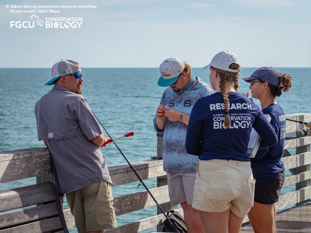
Sea turtle recreational bycatch at the Venice Fishing Pier
PIs: Matt Ware (FGCU), Robby Brannum (Florida Fish and Wildlife Conservation Commission)
Applications for FGCU students to join the 2026 surveys are currently closed.
Working as part of a larger project along Florida’s Gulf Coast with the Florida Fish and Wildlife Conservation Commission (FWC), Florida Gulf Coast University is conducting surveys of anglers on the Venice Fishing Pier to assess rates of sea turtle bycatch in recreational fisheries. During these surveys, students chat with members of the general public to investigate:
- What fishing practices are currently in use at the Venice Fishing Pier?
- How many individuals of which sea turtle species and life stages call the Venice Fishing Pier home?
- How frequently do sea turtles interact with these recreational fisheries?
- What is the typical angler response to a sea turtle entanglement or hooking?
- What actions, trainings, signage, or other interventions would be welcome to ensure affected sea turtles and other wildlife receive appropriate veterinary care?
Venice Pier is the southernmost of seven sites FWC is coordinating with to conduct this work. 2025 was Year 1 of this project with follow-on work planned for the 2026 season.
Stay tuned for more details!

Sea turtle nesting dynamics on Cayo Costa and Don Pedro Island State Parks
PIs: Matt Ware (FGCU), Jacob Wozny (Florida Department of Environmental Protection), and Jennifer Yavonne-Walker (FDEP)
Applications for FGCU students to join the 2026 surveys are currently closed.
Florida Gulf Coast University has partnered with the Florida Department of Environmental Protection to monitor sea turtle nesting activity on Cayo Costa and Don Pedro Island State Parks. Students patrol ~7.5 miles of these beaches each morning during the nesting season to identify new crawls, protect and monitor incubating nests, and collect productivity data. This fundamental data is utilized by the state wildlife agencies (e.g., Florida Fish and Wildlife Conservation Commission) to assess state-wide trends in, and threats to, these protected species. In addition, students have the opportunity to conduct individualized research projects related to sea turtle and beach conservation. Among these questions include:
- What is the current habitat distribution on the state parks?
- How are the various sea turtle species currently using the full spatial extent of the state parks?
- What relationships do these species distributions have with available habitat and environmental variables (e.g., elevation, temperature, moisture, distance to the water table/shoreline/upland vegetation, sediment grain size)?
- How do these relationships impact productivity (e.g., clutch size, hatching success) and offspring fitness (e.g., size, crawl speeds)?
- How have these distributions and relationships changed through time in response to hurricanes, anthropogenic management, or other factors?
Stay tuned for publications and other virtual materials related to this work!
FGCU360: Meet the Eagles protecting sea turtle nests in Southwest Florida
>> https://fgcu360.com/2025/12/05/meet-the-eagles-protecting-sea-turtle-nests-in-southwest-florida/
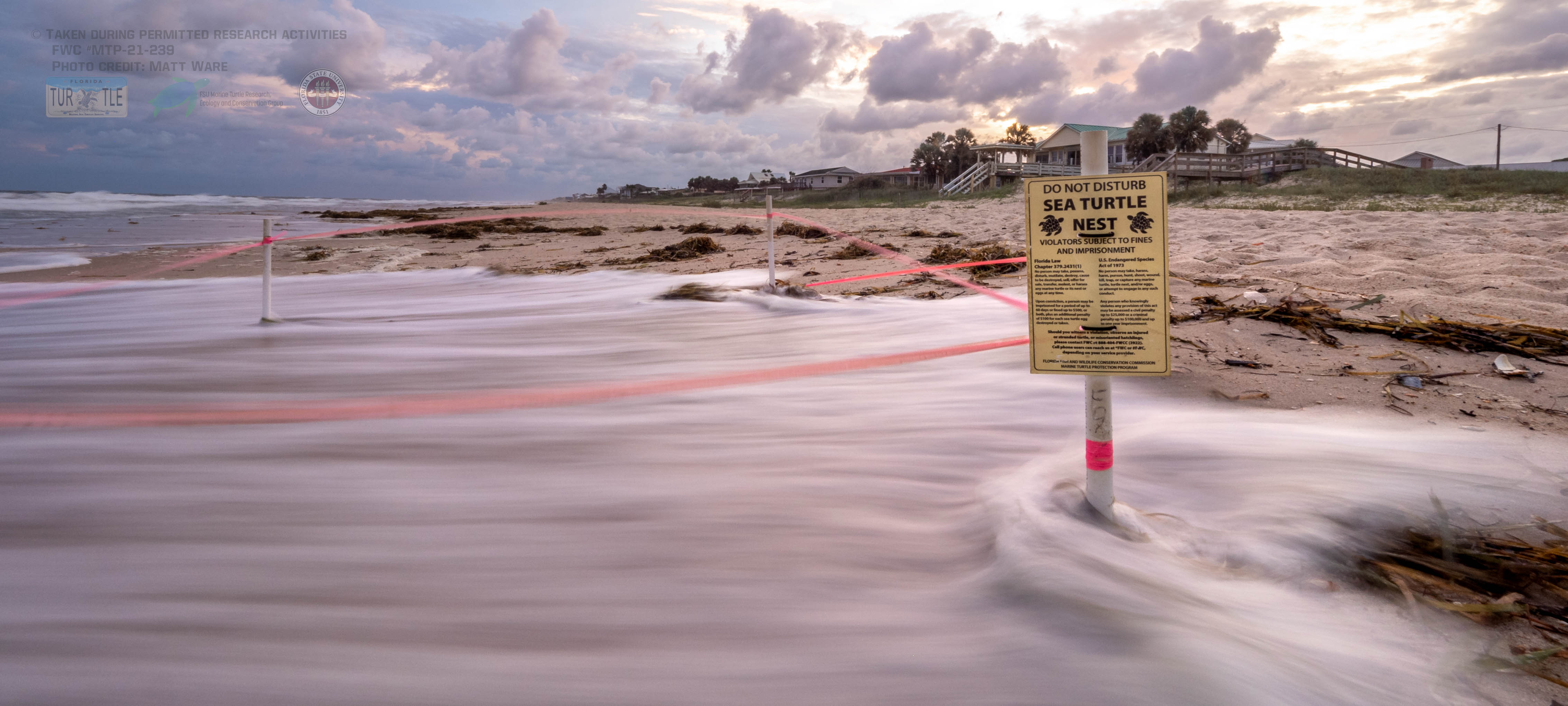
Wave exposure and inundation of sea turtle nesting beaches
Collaborators: Matt Ware (FGCU), Paul Hillbrand (BHIC), Elizabeth Darrow (BHIC), Elizabeth Pinnix (NCCR/NERR), Joe Long (UNCW), Mariana Fuentes (FSU), Simona Ceriani (FL FWC), Alabama Coastal Foundation Share the Beach, Bon Secour NWR, Apalachicola NERR
Funding: Florida Sea Turtle License Plate Grant Program administered by the Sea Turtle Conservancy, Alabama Department of Conservation and Natural Resources, FSU Winchester Scholarship, and Florida State University. Equipment toward this project has been donated by Onset Computer Corporation.
Inundation and nest erosion from wave exposure, storm surge, and sea level rise are major threats to sea turtle nests – causing mortality as well as potential changes in hatchling size, morphology, locomotor function, and sex. Female turtles use several environmental cues when deciding where to nest such as beach slope, tide height, and distance from the water to reduce the chances of wave exposure. However, waves are still a common problem and increasing storm intensity and coastal development only exacerbate the issue. Identifying where and under what conditions wave exposure becomes a problem, and deciding what action to take (if any), is a common issue for sea turtle managers. For example, before we can consider any management action or intervention ranging from beach preservation to nest relocation, we need to know:
- At what frequency or duration of exposure does wave wash-over cause significant harm to developing turtles?
- Do these exposure thresholds vary with the developmental stage of the embryo?
- How does this tolerance (or lack thereof) vary across species and populations?
- What are the benefits of non-lethal levels of wave exposure, including reduced incubation temperatures, increased male hatchling production, large body sizes, and/or faster crawling speeds?
- Would relocating nests introduce other threats which may cause as much (or greater) impact than wave exposure in their current location, such as hyperthermia, increased female hatchling production in a female-dominant population, desiccation, and increased predation or orientation?
- How is wave exposure likely to change in the near future due to coastal development, armoring, beach erosion, hurricane frequency and strength, and sea level rise?
- How may sea turtles naturally adjust their nesting behaviors to combat these changing beach conditions?
To help inform conservation initiatives to combat this threat, we can use nest location and productivity data, beach elevation data, and wave runup modeling to:
- Identify the reduction in loggerhead sea turtle hatchling production caused by wave exposure,
- Map out which beaches represent priority areas for conservation initiatives, and
- Investigate the efficacy and consequences of various management actions for the individual clutch, broader population, and coastal ecology

Following these modeling exercises, we can collect in situ information such as the frequency of wave exposure, its duration, hatchling production, and other data to close the information gaps and better inform management decisions. For example, St George Island was identified as a priority area for wave exposure impacts based on wave runup mapping in the Florida Panhandle. In 2021, we monitored wave exposure and inundation across the nesting beach throughout the nesting season to begin describing embryonic tolerance to these threats following the blueprint laid out by previous work on the Fort Morgan Peninsula of Alabama from 2016-2018.
This previous work concentrated on wave exposure, inundation, and the role of nest relocation in mitigating this threat. Though moving “at risk” nests may be a common sense approach to dealing with inundation, relocation can 1) result in the loss of developing embryos through the disruption of embryonic membranes, 2) increase the production of female hatchlings by changing the eggs’ incubating environment, and/or 3) increase predation from coyotes, foxes, raccoons, birds and other predators by moving the nest closer to their preferred hunting habitat and increasing the distance hatchlings must crawl to the water. There may also be sublethal effects such as reduced muscular development as a result of the altered incubation environment. Nest relocation on the beach or into a hatchery, beach renourishment, Leave No Trace ordinances, refugia protection, and other management actions all need to be investigated in order to determine under what circumstances each may be effective.
Publications in this project and related literature:
- Ware et al. (2021) Exposure of loggerhead sea turtle nests to waves in the Florida Panhandle. Remote Sensing 13(14): 2654.
https://www.mdpi.com/2072-4292/13/14/2654 - Ware et al. (2019) Using wave runup modeling to inform coastal species management: An example application for sea turtle nest relocation. Ocean and Coastal Management 173: 17-25. DOI: 10.1016/j.ocecoaman.2019.02.011.
https://www.sciencedirect.com/science/article/abs/pii/S0964569118310202 - Fuentes MMPB et al. (2019) Exposure of marine turtle nesting beaches to named storms along the continental USA. Remote Sensing 11(24): 2996.
https://www.mdpi.com/2072-4292/11/24/2996 - Ware M, Fuentes MMPB (2018) Potential for relocation to alter the incubation environment and productivity of sea turtle nests in the northern Gulf of Mexico. Chelonian Conservation and Biology 17(2): 252-262.
https://chelonianjournals.org/doi/abs/10.2744/CCB-1306.1?journalCode=ccab - Ware M, Fuentes MMPB (2018) A comparison of methods used to monitor groundwater inundation of sea turtle nests. Journal of Experimental Marine Biology and Ecology 503: 1-7.
https://www.sciencedirect.com/science/article/pii/S0022098118300121
Habitat mapping and suitability modeling for protected species
PIs: Matt Ware (FGCU), Joe Long (UNCW), Stephanie Kamel (UNCW), Elizabeth Pinnix (NCCR/NERR), Beth Darrow (BHIC), Paul Hillbrand (BHIC)
North Carolina is situated at a unique and significant confluence of physical and anthropogenic factors relevant to several species of conservation concern, including sea turtles, shorebirds, terrapins, and marine mammals. The barrier islands, Intracoastal Waterway, sounds, bays, estuaries, and other coastal habitats provide a range of ecosystem services including storm and flood protection for upland developments; commercial harvesting; recreation (e.g., fishing, boating, beaches); nutrient cycling; water filtration; and habitat for foraging, breeding, and other biological functions for a myriad of coastal species. Identifying the current distribution of available habitats, the suitability of these habitats to provide ecosystem services, and how this may change in the future under climate change, sea level rise, hurricanes, dredging, and/or coastal development scenarios is critical for conservation management and urban planning.
Masonboro and Bald Head Islands are of particular interest. Masonboro is the largest remaining undeveloped barrier island in southeast North Carolina. As one of the four National Estuarine Research Reserve (NERR) sites in North Carolina, it is home to ocean-facing beaches, Spartina salt marshes, tidal creeks, and a string of dredge spoil islands which separate the NERR from the Intracoastal Waterway. Throughout the year, these habitats host loggerhead (Caretta caretta) and green (Chelonia mydas) sea turtles, diamondback terrapins (Malaclemys terrapin), American oystercatchers (Haematopus palliates), Wilson’s (Charadrius wilsonia) and piping (C. melodus) plovers, least terns (Sterna antillarum), and several mammals including red fox (Vulpes vulpes), coyotes (Canis latrans), and raccoons (Procyon lotor). That’s not including the extensive human use of the island for recreation and commercial purposes given it’s close proximity to the city of Wilmington!
Bald Head Island is a barrier island at the mouth of the Cape Fear River a few miles south of Masonboro. Bald Head Island has an extensive beach and marsh ecosystems, supporting a small residential population (~300 people) and a healthy tourism industry. The Bald Head Island Conservancy (BHIC) has been monitoring and protecting the island’s species and environments since 1983, producing one of the longest-running sea turtle tagging and nesting records in the country.
Combined, these two islands are the third largest sea turtle nesting site in the state of North Carolina. These beaches are critical for the long-term recovery of sea turtle populations in the the southeast United States as North Carolina is currently the northern limit of regular sea turtle nesting, meaning incubation conditions here may support more balanced hatchling sex ratios and opportunities for range shifts in response to climate stressors than beaches further south.
Balancing the continued human reliance on the island with its ecological health requires an understanding of the current distribution of habitats, species, and physical variables throughout the site, as well as how these may change under different future scenarios. This project therefore seeks to answer:
- What is the current habitat/land cover distribution on Masonboro and Bald Head Islands?
- How are species of conservation concern currently distributed on the island in both space and time?
- What relationships do these species distributions have with available habitat classifications and other physical environmental variables (e.g., elevation, temperature, moisture, distance to the water table/shoreline/upland vegetation, sediment grain size)?
- How do these relationships impact productivity (e.g., clutch size, hatching success) and offspring fitness (e.g., size, time to fledging) for protected species?
- How have these distributions and relationships changed through time in response to hurricanes, anthropogenic management, or other factors?
- Under various future scenarios (e.g., hurricane exposure, sea level rise, increasing atmospheric temperatures, dredge spoil deposition), will Masonboro and Bald Head Islands continue to provide sufficient habitat suitable to sustain protected species?

Collecting data to address these questions involves a truly integrative, interdisciplinary approach. Quarterly drone flights (AKA UAS: unmanned aerial system or UAV: unmanned aerial vehicle) provide very-high resolution (~3cm ground sampling distance) imagery to generate orthomosaics for deep learning-based habitat classification and 3D elevation point clouds based on structure-from-motion algorithms. Though starting with 3-band RGB imagery, aerial sensors may ultimately include near-infrared bands, thermal bands, and LiDAR, and will be supplemented with satellite imagery. This aerial data is paired with in situ monitoring efforts such as daily nesting surveys, RTK GPS surveys, instrumentation deployment (e.g., weather stations, water level sensors, temperature loggers), and sediment sampling conducted by the North Carolina Coast Reserve & National Estuarine Research Reserve (NCNERR), BHIC, and UNCW personnel. Given this breadth of data, statistical models addressing the relationships between the habitat, physical environmental, and species distribution and productivity can be evaluated and, assuming such relationships hold in the future, changes to species’ use of the island can be investigated by altering the input habitat or environmental variables based on the best available projections.
Stay tuned for publications and other virtual materials related to this work!
